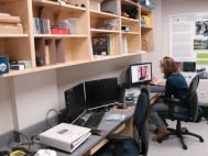
Nipissing Earth Observation Laboratory (R220)
This laboratory is used primarily for the analysis of digital remotely sensed imagery acquired from various satellite platforms including Landsat, SPOT, Radarsat-1 & 2, RapidEye, ENVISAT ASAR, ALOS PALSAR/AVNIR-2, Quickbird WorldView-2 and IKONOS. There are two main PCs which support the most updated versions of PCI Geomatica, ENVI, SAR Polarimetry Workstation and Definiens Developer. An ASD FieldSpec HandHeld Portable Spectroradiometer is available for field data collection.
Biophysical inventorying equipment stored in the lab includes one LAI-2000 Plant Canopy Analyzer, two AccuPAR LP-80 Ceptometers, one LI-3050C Portable Area Meter, Leica DISTO distance meters, Suunto clinometers, DBH tapes, spherical densiometers, BAF2 prisms and two HOBO Micro Station Data Loggers equipped with Photosynthetic Active Radiation sensors.
GPS equipment includes two GPS Pathfinder ProXT receivers, two Trimble 400C Recon Units, one Trimble GeoXT, two Trimble Hurricane Antenna Kits and respective software (Trimble, TerraSync Professional and Pathfinder Office). An older sub-metre differential GPS unit is also held in the lab (2 Ashtech SCA-12 receivers, Husky data collector and 2 external antennas).
The lab is supported by NSERC funding awarded to Dr. John Kovacs. For further information please contact him at 705.474.3450 (ext. 4336/4347) or johnmk@nipissingu.ca.
